St Lawrence’s was one of the wards I transcribed before I got the idea of photographing the schedules. It is the ward where I would most like to go back, film the returns and re-assess many of them. Although short, it was not an easy ward to tackle, and an upcoming trip to Toronto meant I was in a hurry and probably did not give the transciption the time it deserved.
The ward included the eastern waterfront and stretched from Yonge Street to the Don River, going north as far as King Street. It contained St Lawrence Market and many businesses catering for market activity: hotels, restaurants, stables, etc. The courthouse and the Corporation of Toronto offices were also here. It was the location of many lawyers’ chambers. King Street was also the commercial hub of the city and contained many dry goods stores and boot and shoemakers. Surprisingly, there were also a number of photographers’ studios.
To the east of the market Palace Street was a mixture of small shops and dwellings with a cluster of hotels and boarding houses. East again and we find Gooderham’s Distillery, a railway area centering around Don Station, and the Toronto Rolling Mills where steel plate was made. Along the shore of the Bay were a number of commercial wharves. Although the census was taken in January, some people were living right on the wharves. It must have been very cold, uncomfortable and unhealthy.
Because of the nature of the ward, the census included numerous schedules giving the title of the business or the owner’s name, very few personal details, and the words “Personal Census Taken at Residence”. Some of these would, in addition, list young men living at their employer’s place of business. I wasn’t prepared for this presentation and taking notes around it took more time than I would have expected. Recently, in doing St George’s, a ward with many similarities to St Lawrence’s, I have adopted the initials PCAR into my initial transcription of the business owner’s line.
One of the enumerators must have suggested that everyone fill in their forms in pencil. He then wrote over the pencil with a very broad penknib, editing bits he though unnecessary as he went. So much for householders’ individual responses in that area!
Street names were seldom omitted in St Lawrence’s Ward. With the great variety of types of premises, it was just as well.
Monday, 20 April 2009
Sunday, 19 April 2009
A Momento of St George's Ward

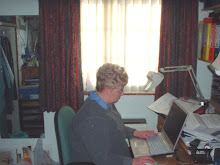
Last week I was able to take this photograph during my progress along Front St West.
We know John Toronto better by the name Bishop Strachan. At the time of the census he was 83. He had been a bulwark of religious and political life in Toronto since his arrival there in 1812. Many of his contemporaries respected him, many disliked him, but he was one of the most prominent men of his time in Toronto.
For an online biography, see The Dictionary of Canadian Biography (http://www.biographi.ca/index-e.html?PHPSESSID=b983dmdth512rlcaa2gc073bb4)
Tuesday, 7 April 2009
St David’s Ward—Chapter Three
Having strayed more into the realms of geography for the past two blogs, I am now going to try and get back to a topic more closely related to genealogy. Where did the people of St David’s Ward come from?
When transcribing, most of the birthplaces were entered as found, though I tended to use a uniform abbreviation for Upper Canada or Canada West. If someone was specific down to the town or county of Ireland or England, I put it in—so long as I could read it. For the purposes of this analysis, however, I separated the birthplaces into 23 categories spreading out from Toronto, first to the rest of the North American continent, then to the British Isles, and then to the remainder of the world.
Within the province of Canada West there were four categories: Toronto, elsewhere in York County, Canada West outside York County, and simply, Canada West. The volume of “Canada West” and “Upper Canada” responses lead me to assume that this category was the one that enumerators were expected to advise to householders, and the one they would use if they had to fill in the forms themselves.
The birthplace claimed by the greatest number of people was Ireland with 31.9 percent of the total. The next place was Canada West with 26.9 percent. When Toronto and the two intervening categories were added to it, the proportion bumped up to 35 percent, quite a bit more than Ireland. Needless to say, the locally born were the younger section of the population and St David’s had 40 percent under age 16. When the ages of the population are presented against their birthplaces, the Irish markedly outweigh the locally born from age 16 upward. The census took place less than 15 years after the potato famine. It shows.
There is no distinction made between Northern Ireland and the Irish Republic either in the census or in my analysis. The border that exists today was not put in place until the 1920s.
The third most commonly given birthplace was England with 13.6 percent of the total. “Canada” came in next at 6.8 percent. In fourth position was Scotland with 5 percent and the United States was fifth with 2.3 percent.
We must remember that at the time Canada only comprised what we know as Ontario and Quebec. The maritime provinces were still separate entities. It is possible that some enumerators suggested Canada instead of Canada West. In Divisions 5 and 6 there were many more people born in “Canada” than in “Canada West”, although the number born in Canada East (or Lower Canada) did not drop significantly in those two divisions.
Although the first Toronto General Hospital was built on Gerrard St East between Sackville and Sumach and opened in 1856, there is nothing to indicate its presence in the census. The staff and patients are probably to be found in a separate section titled “Institutions” which I have yet to see. The inmates of the Don Jail are probably there as well.
If you want to see what St David’s Ward looked like, I suggest you spend a while browsing through the old photographs in the Toronto Public Libraries collection online. The link is http://historicity.torontopubliclibrary.ca/ where it is best to put “Cabbagetown, pictures” or “Regent Park, pictures” into the keywords box. If you live in Toronto there is another collection, analysed street by street, at City of Toronto Archives just north of the Dupont subway station at 255 Spadina Road.
Monday, 6 April 2009
Off Topic
Today is April 6th and it would be appropriate for me to celebrate the birthday of my great-grandfather's eldest brother, Newyear.
Newyear? Yes, Newyear. I didn't know anything about him until I had been investigating my family history for ten years or so. He was born somewhere in the United States in 1832. By 1839 the family was living in Kingston, Ontario, and a year or two later moved to a farm in what is now Scugog Township, Durham Region. He married in the 1850s and established his own farm in Bruce County. He had several daughters and one son.
Why Newyear? Well, April 6th is the first day of the year in the old Julian calendar that was used until the 1750s in England. It is still the first day of the financial year in England. Newyear's parents were both English, one or both of them must have recognized the significance of the day. I would like to think that the historian was my ggg grandmother, Martha.
Martha is a mystery to me. She and her husband George both gave England as their birthplace on Canadian censuses. Like her husband she must have emigrated to the States. Somewhere they met and started their family. But that's all I know. Even her maiden name is a mystery. She died as "relict of George". Frustrating.
Sunday, 5 April 2009
St David’s Ward—Chapter Two
My last blog was a brief description of the ward from a geographical point of view. In this one I want to tell you some things about the people who lived there.
The total population, according to the census, was 7846—of which 3804 were male and 4042 were female. Both sexes were pretty evenly matched in numbers throughout the age range but, between the ages of 16 and 35 there were definitely more females. In the days before many girls had an occupation, they stayed home, while their brothers were in a better position to wander and establish themselves elsewhere. Children under 15 accounted for just over 40 percent of the population. Only 250 people (3 percent of the total) were over 60 and another 5.3 percent were in their 50s. Those who did not give their age or whose ages, for some reason or other, were unreadable amounted to 122 or 1.6 percent. That left 1816 males and 2142 females between the ages of 16 and 50 (47.7 and 53.0 percent respectively).
The population breakdown between the divisions was as follows:
Division One (King St East to Duchess Street, Nelson Street to Caroline Street) 953 people
Division Two (King St East to Queen, Caroline Street to Parliament Street) 1434
Division Three (Duchess & Queen St East to Caroline St, Jarvis St to Parliament St) 2423
Division Four (King St East to Beech St , Parliament St to the Don River) 1881
Division Five (Carlton St to Bloor St East, Jarvis St to Parliament St) 413
Division Six (Beech St north to Bloor St, Parliament St to the Don River) 778
Three of the four streets bounding Division One have had their names changed since the 1860s. Duchess Street is now the eastern part of Richmond St East, Nelson Street is Jarvis Street below Queen, and Caroline Street is now the southern part of Sherbourne Street. In terms of physical area, it was the smallest of the divisions, but probably the most densely populated. On King Street there were many families living “over the shop”.
Division Two extended east from Division One and also added another block north so that it reached Queen. It was still quite densely populated and contained many small shops.
Division Three was much larger in area than Divisions One and Two. Jarvis Street was the home of many merchants and barristers. George Street, which parallels Jarvis, was more likely to contain the homes of workers.
Division Four extended east from Division Two and the two divisions were quite similar, although the density of population continued to ease the more one moved from the centre of the city. On the streets adjacent to the Don River were a number of butchers. This was probably an area where cattle could be kept for a short time immediately before being herded down to St Lawrence Market.
Divisions Five and Six could be considered the “suburbia” of the time. Only a few years before the area was called “The Liberties” and was not exactly part of the city. People were just moving into this area. Division Five was a continuation of Division Three with many merchants, bankers, and a small academic community stretching out from the Normal School and the Medical College situated east of Jarvis. Division Six included not only St James’s Cemetery, but Lamb’s Blacking Factory—the glueworks which formed the location of one of the episodes of Murdoch’s Mysteries.
Saturday, 4 April 2009
St David’s Ward—Chapter One
St David’s was the first city ward I attempted to transcribe. Although I had done a lot of transcribing before, including both the 1851 and 1861 censuses for York Township, tackling a census form which individual families had filled in was definitely a new process. Reading writing styles which changed from page to page was one challenge, understanding how different people interpreted the instructions was another.
St David’s stretched from Jarvis Street east to the River Don and from King Street East to Bloor, or “the Second Concession”. The southern part of the ward was densely populated but the number of houses in the quarter east of Ontario Street and north of Queen was definitely less. North of Gerrard Street there were even less people. It is hard to imagine this area as thinly populated as it was in the early 1860s. Today we know much of it as Regents Park, where two or three large schemes of urban renewal have taken place during the 20th century to improve the quality of residential accommodation left from earlier times.
The street names were not methodically added to the forms by the enumerators, and this has made it difficult to establish the boundaries of the six divisions into which the ward had been divided. It has also been very difficult to identify families in the Caverhill (1859) and Mitchell (1863) Directories because so many people moved so much during those 4 or 5 years.
Most people had many fewer possessions than we do. It was simpler to rent a house than buy one; leases may have been unknown and a mortgage was probably out of the question for most families. Moving house was probably a much simpler proposition for them than it is for us.
Recently I decided for the nth time to see if I could figure out where all the streets were where the enumerator had not put them on the individual schedules. I had tried to do this before, but usually hit upon an operation that took so long that I never found the answer. This time I took my Access database and made a query asking for a list of the number of households on each street within each Division. I transferred the list to a spreadsheet and sorted the list by division and then by street. What do you know--most of the households without an address were in Division 3, something I hadn’t realized before.
I made a copy of a map that I had scanned from Toronto in the 1850s and, using a free image-enhancing software package called Paint.net, I outlined the five divisions for which I had streets. Presto! Division 3 was the empty space. And what an important one. The western boundary was Jarvis Street, the eastern one Parliament, the south Queen East and the north, Gerrard—the territory many families were moving into as they found their circumstances becoming more comfortable.
This is only the beginning of the story of St David's Ward. Chapters Two and Three are on their way.
Subscribe to:
Posts (Atom)